Pavlopetri: Dive in History
Pavlopetri, the Ancient Submerged City off Elafonisos
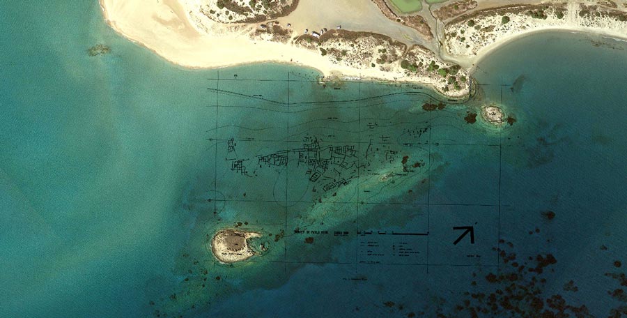
Seven hundred meters northeast of Elafonisos, a small island emerges, always frequented by seabirds. Its name is “Pavlopetri,” from which the entire surrounding area derives its name. The islet of Pavlopetri, a second rocky islet approximately 400 meters away, and the coast of Pounta form an isosceles triangle, within which the remains of a submerged settlement are preserved, dating back 5,000 years…
PAVLOPETRI According to recent research, it is one of the oldest submerged cities in the world, spanning about 50 acres. It includes intact views of architectural complexes, courtyards, roads, chamber-like structures, and box-shaped tombs. Specifically, ceramic fragments collected by archaeologists led to the conclusion that it is a prehistoric settlement first inhabited in the Final Neolithic period, from 4500-3200 BCE. It extends through all three phases of the Bronze Age but flourished particularly in the early 3300-2000 BCE and the late Bronze Age 1600-1100 BCE (Mycenaean Civilization). A rare phenomenon exhibited by Pavlopetri is its continuous occupation from 3000 to 1100 BCE.
Some researchers suggest that the size and location of Pavlopetri possibly indicate it was the capital of the Vatika plain in the prehistoric period. Additionally, Pavlopetri is situated at the crossroads of “Elafonisos-Kythira-Antikythera-Crete,” making commercial connections with these areas highly plausible. Fragments of pithoi and woven weights found may confirm both commercial and craft activities of that era. Overall, the ceramic fragments recovered seem to display influences from Minoan, Kythirian, Cycladic, and Laconian patterns. However, only extensive excavation can reveal the true role of Pavlopetri during this extensive chronological period.
Of particular interest is the fact that this underwater settlement is accessible to visitors. The water is clear, and the depth does not exceed 3 meters, allowing anyone with a pair of snorkeling fins and a mask to explore the area, discover the streets of the settlement, the foundations of buildings, tombs, and experience firsthand its unique power and magic. Access is also possible from land, including the Cemetery on the Pounta coast, the quarry, the channel, and the Round Lake. Visitors are encouraged to explore Pavlopetri with absolute respect and love for the environment.
Finds from the prehistoric settlement of Elafonisos are exhibited at the Archaeological Museum of Neapolis. Moreover, the Archaeological Museum of Pylos in Niokastro includes in its collection two pithoi recovered from Pavlopetri during the excavation in 2011.
DISCOVERY OF PAVLOPETRI In 1904, geologist Fokionas Negris was the first to notice the architectural remains of the submerged settlement. However, the significance of this discovery was not widely recognized at that time. His observations were later confirmed several years later by oceanographer Nicholas Flemming during his visit to the area in 1967.
The true importance of the discovery became apparent in 1968 when an underwater exploration mission was organized by the underwater exploration team of the University of Cambridge, aiming to study the architectural remains and gather information about their chronology and how the area sank. The team, along with a Greek archaeological team led by the renowned archaeologist Angelos Delivorias, spent six weeks in the area, meticulously recording the visible submerged remains using a kind of grid composed of intersecting lines. However, this archaeological investigation did not involve excavating the site but focused on the surface collection of artifacts. The ceramic fragments collected by researchers led to the conclusion that it was a prehistoric settlement spanning all three Bronze Age phases (early, middle, late) but thriving particularly in the early and late periods, including the Mycenaean era.
Findings and Structures: The visible remains in the underwater location were divided by the archaeological team into 10 sectors (A-K), where 15 houses were distinguished, consisting of a series of rooms usually around 10 in number. Considering that a house with ten rooms on the ground floor could accommodate around 20 people, including children and servants, this suggests a population of 600 inhabitants. However, the actual number may have been much larger. Among the structures, no two were alike, but a recurring feature was a large central room, usually rectangular, possibly serving as an internal courtyard.
Time and the underwater environment have evidently left indelible marks on the remains of the submerged settlement. Therefore, what we can see today is only the elevation of the city’s buildings. This is because only the foundations of the houses were made of stone (stones in the foundations were necessary to prevent moisture and erosion from rainwater flowing through the streets). The upper parts of the walls, constructed of unbaked bricks made from clay and straw, created with molds and dried in the sun and air, were supported by this stone base. Thus, after the submersion of the settlement, the walls were completely destroyed. This particular construction method had been adopted in many other parts of the Peloponnese, even 50 years earlier.
Building with Ritualistic Characteristics Among the structures, there is one with a distinctive architectural style that appears to belong to an earlier period. The eastern side of the building is actually made up of only ten stones. On the northern and southern ends, there are small ridges made of presumably smaller stones, and several stones stand on their sides, resembling the sides of a rectangular tomb. Three conical cups from the Early Helladic period were found among the stones of the building’s walls, suggesting that it may have been used for funeral rituals. Only further excavation can provide more information about the dating and nature of this specific building.
The roads of Paulopetri have a width of about 5 meters, and a distinctive feature is that they are constructed from the straight lines of the houses, a characteristic that can also be observed in the construction of modern Elafonisos. They are also filled with small stones and occasionally paved. However, the paving may not be human-made but a result of walls being demolished over time due to the action of waves.
Ark-shaped Tombs An integral feature of the underwater site is the approximately 40 ark-shaped tombs. They can be found among the buildings of the submerged settlement, under the floors of the houses, and even within walls. They consist of four upright limestone slabs, usually forming a rectangular parallelepiped. A fifth slab covers the burial.
Cemetery on Land The archaeological team also mapped the extensive cemetery on the coast of Pounta, which includes at least 60 rock-cut tombs. Some tombs have been partially or completely destroyed during the construction of the channel leading to the salty Stroggili lake and subsequent quarrying activities. Moreover, several of these tombs are now underwater.
Quarry, Channel, Stroggili Lake Visible traces of schist quarrying can be observed on the coast, possibly dating back to the Roman period. The existence of the quarry may be related to the opening of the channel, which has cut through three tombs of the cemetery. Its purpose was to channel water to Lake Stroggili for evaporation into salt. A bridge, possibly constructed for the quarry’s operations, was recorded by a British archaeological team in 1968. Unfortunately, it has been completely destroyed due to ignorance or negligence.
2009: New Research Period After the 1968 survey, Paulopetri was declared an archaeological site, and its protection was undertaken by the Ephorate of Underwater Antiquities of the Ministry of Culture. In 2009, the Ephorate, in collaboration with the University of Nottingham and the British School at Athens, initiated a five-year program to outline the history and evolution of the submerged city of Paulopetri. The general direction of the mission was led by the renowned archaeologist Elias Spondylis, with extensive experience in many submerged settlements in the wider region of Laconia. The program, in cooperation with the Hellenic Centre for Marine Research, aimed to determine how and when Paulopetri and the Strait of Elafonisos were submerged.
New Findings Using advanced technology, archaeologists identified the known extent of the remains from the 1968 mission and discovered and mapped over 9,000 square meters of new architectural complexes, likely covered by sand deposits over the years. The influence of waves and marine currents in the area is evidently associated with the movement of a large volume of sand to the northern side of the area. Among the findings were four new ark-shaped tombs and an unburied pit burial. This is confirmed by the absence of marine algae and organisms (mainly sponges and sea urchins) on the new masonry compared to the earlier areas discovered in 1968. With the new research, the extent of the submerged settlement increased from 30 to approximately 50 acres.
Additionally, the 2009 survey brought to light new ceramic evidence indicating that the area was inhabited for the first time in the Final Neolithic period, not in the Early Helladic II, as was previously accepted. The ceramic material from the Final Neolithic period shows affinities with findings from contemporary settlements and cave areas in Laconia. The discovery of some ceramic fragments dating to the Protogeometric, Classical, Hellenistic, Roman, and Byzantine periods extended the period of later habitation of the settlement or its parts into late antiquity. It is evident that we are dealing with continuous habitation of the underwater site, and only further archaeological excavation will shed more light on when and how this specific settlement flourished and was eventually destroyed.
Excavation Research 2011 and Findings In 2011, the first excavation research was conducted in the settlement. Specifically, two trenches were made at points where the outlines of buried pits were visible. From the first trench, two pits were recovered, which were later joined by the conservators of the Ephorate of Underwater Antiquities. Of particular interest is the construction of the second pit, as it consists of three different pieces. These pits can be observed up close at the Archaeological Museum of Pylos in Niokastro. Moreover, artifacts from the prehistoric settlement of Elafonisos can also be seen at the Archaeological Museum of Neapoli.
Search
Latest Posts
What are you interested in?